Corozal District, Belize
Corozal District blends ancient Maya heritage, Caribbean coastlines, sugarcane country, village culture, art, and cross-border Belize–Yucatán history into one of Belize’s most distinctive northern landscapes.
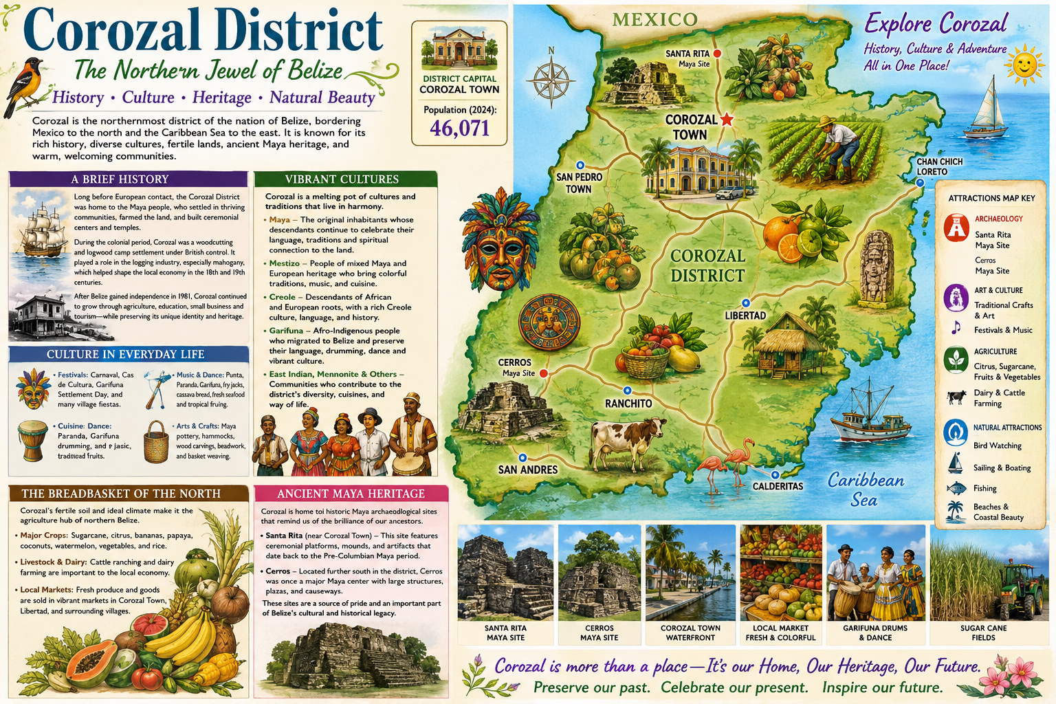 Corozal is Belize’s northernmost district, bordered by Mexico to the north and the Caribbean coast and Corozal Bay to the east. Its district capital, Corozal Town, sits only a short distance from the Mexican border, giving the area a distinctive northern Belize character shaped by Maya heritage, Yucatán connections, agriculture, fishing, trade, and cross-border cultural exchange. The district’s 2024 population is listed at about 46,071, with Corozal Town serving as its main civic, commercial, and cultural center.
Corozal’s history reaches far back into the ancient Maya world. Two of the district’s most important archaeological sites are Santa Rita, located near modern Corozal Town, and Cerro Maya / Cerros, on Corozal Bay. Santa Rita is widely associated with the ancient Maya city of Chetumal, a powerful settlement connected to trade routes linking the Caribbean coast, the Río Hondo, the Río Nuevo, and inland Maya centers. Cerros, set near the water, reflects the importance of coastal trade and ceremonial life in the Preclassic Maya period. Both Santa Rita and Cerro Maya are recognized archaeological sites under Belize’s National Institute of Culture and History.
The modern district also reflects Belize’s layered cultural story. Corozal is strongly influenced by Maya-Mestizo heritage, especially through families whose roots connect to the Yucatán Peninsula and the historic movement of people into northern Belize during and after the Caste War period. Spanish and English are both widely heard, and local identity often blends Belizean, Yucatec, Caribbean, and borderland traditions. The wider district includes Maya, Mestizo, Creole, East Indian, Mennonite, and other communities, each contributing to its foodways, languages, farming traditions, crafts, music, and community life.
Agriculture remains central to Corozal’s economy and landscape. The district is part of Belize’s northern sugar belt, with sugarcane fields, farming villages, and agro-processing tied closely to daily life. A 2023 agriculture-sector social assessment notes that Corozal has long focused on agricultural production and services connected to the nearby Mexican market, with agriculture providing the largest share of employment in the district. Sugarcane has historically been the dominant crop, while traditional milpa agriculture, local produce, livestock, and small-scale farming continue to shape rural life.
For visitors, Corozal offers a quieter alternative to Belize’s more heavily touristed areas. Attractions include the Corozal waterfront, Corozal Bay, nearby Maya sites, fishing, local food, village visits, art and cultural events, and access to nearby nature areas such as Shipstern Nature Reserve. Its appeal is not only in individual attractions, but in the combination of coastal scenery, Maya history, agricultural landscapes, and living northern Belize culture.
Sources
- Data Commons / Corozal District population, 2024 estimate: 46,071.
- Corozal District overview, capital, location, demographics, and Maya ruins at Santa Rita and Cerros.
- Belize National Library Service — Mestizo history in Belize and migration during the Caste War of Yucatán.
- UNICEF Belize — Corozal’s Maya history and its association with the development of Mestizo culture in Belize.
- Santa Rita Corozal archaeological information, including its location within Corozal Town and long Maya settlement history.
- Cerro Maya / Cerros archaeological site information, including its location in Corozal District and Preclassic Maya history.
- Belize sugar industry background, including sugarcane cultivation in Corozal and Orange Walk.